Surrounded by mountains, I’m in a hunt for panoramic views. With peaks well over 2000 meters above sea level this shouldn’t be too hard. But what if there’s more than just a majestic views? Today I visit the Stoanernen Madln in Süd Tyrol by the hands of Marion, my guide for today.
The post Majestic panorama at Stoanernen Mandln appeared first on Live & Explore.
]]>The Stoanernen Mandln are a big collection of piles of stone. Some of these piles reach as high as the average human length. Collected at the top of the Schöneck plateau it definitely adds an extra dimension to the already spectacular views over the valley and mountains around.


What are the Stoanernen Mandln?
It rises a question though. What are these man of stone doing here? There are at least a 100 of these piles of stones gathered around the cross.
The story goes that it’s a place was used by witches. In fact, there are legal documents dating back to 1540 that claim these practices. The witches would dance around the stone figures, worship the devil and change the weather, sending violent thunderstorms down the valley.
These stories combined with the mystic Stoanernen Mandln gives this place an enchanting and mysterious atmosphere. Combined with the spectacular views this is a hike you don’t want to miss!
Hike to the Stoanernen Mandln
As in many places, there are tons of ways to get up to the Stoanernen Mandln. The good news is that no matter what way, you’ll be presented with wonderful views along the hike. Common places to start are close to Sarentino or Merano.
The route I share here starts in Vöran and will take you on a 21km long journey. With an ascent of around 996 meters, this route will take you a little over 6 hours excluding stops. While the route itself is not hard, you do need a good condition. The experience and landscape are absolutely worth it though!
Other options to start a hike towards the Stoanernen Madln are from the nearby ‘Parkplatz Grüner Baum‘ or ‘Parkplatz Schermoos‘ in Mölten. Starting from there will reduce the duration of the hike to approximately 4 to 5 hours.
Along the route
Along the route you will pass several restaurants. Note that the opening hours are seasonal. During high season many of these restaurants are open daily while in winter time they may only be open during weekends or even completely closed.


On the map we have marked some of the restaurants so you can keep them in mind while walking around. If you can’t get enough of the beauty in this region, it’s even possible to stay for the night at a couple of these places.
A hike to remember
While it’s not the toughest hike in terms of condition, the hike will still take you a full day to complete. Best of all, in terms of scenery and landscape, it’s one of the prettiest around. If you find yourself in the area in spring time, you’ll be welcomed by lots of flowers as well, giving yet another level of beauty to the hike.
If you are considering this hike or are interested in this region, we’d recommend you to visit the Avelengo, Verano and Merano tourist information website which is part of the region Süd Tyrol.
The post Majestic panorama at Stoanernen Mandln appeared first on Live & Explore.
]]>The post Hiking deep into Nordmarka appeared first on Live & Explore.
]]>It’s another Sunday in December I set out for my second hike near Olso, Norway. This time I’m equipped with the experience from last weeks hike and with that knowledge I go out with a lot more confidence. On the map I’ve spotted a location with lots of little lakes and hills just north of Oslo called Nordmarka.
It’s 10 in the morning and I’m still home, drinking a cup of coffee and gathering some gear. Knowing it gets dark early, this time I’d figure to bring some lights to not get in trouble after sunset. Other than that, I figured it would be wise to bring some more food. Bananas, yes, lot’s of them!
Next up, the weather. The looks from my window are somewhat depressing. It’s very cloudy, but lets stay optimistic, it doesn’t rain! Checking the weather using the Norwegian website yr.no I found that it’s not that cold today. A mere minus 1 to minus 3 is considered warm. It is cloudy though and while it’s most likely not in Olso itself, there might be a very little snowfall. Not the kind of weather that makes me anxious. The chance of some snow actually excites me!

Heading to Nordmarka
Scanning the map, north of Oslo there seems to be a place with loads of relatively high hills and loads of little lakes. Even better, there are even two big lakes called Østre Fyllingen and Bjørnsjøen. “Will they be frozen?” is the first question that comes to mind. Completely inexperienced in this environment, I am determined to find out.
The area I’m looking at is called Nordmarka, the biggest sub region of the Marka area. Marka is the name for the mainly forested region surrounding Oslo. It’s popular by the inhabitants of Oslo for hiking, biking and skiing possibilities. The Norwegian word ‘Marka‘ is the finite form of the word ‘mark‘ and means ‘woodland, forest’. And while I won’t need it today, it hosts many cabins and even for overnight accommodation.
I choose not to plan out a route on forehand, but to just find the location where I can park the car. On the map I find a place called Sørkedalen which is on a little 20 minute drive from Oslo. It has a big parking area so it must be the starting point of something. From there, I had the option to follow some trails and find some of the higher viewpoints or to check out some of the lakes.
Whether I’m going to make it to the big lakes or if I have the time to check out the panoramic view points I don’t know. I’m leaving a bit late and I can see it’s a serious walk to get to the two big lakes. But I got my lights this time, so I’ll see where this journey will bring me.


In for rough start
Driving out of the city, the first thing I notice is that it’s slippery. No, I’m not on foot yet, just in the car, but the advised 60 is for sure not a good idea. Reaching the parking are in Sørkedalen I find that it’s quite busy. Of course I’m not the only one heading out on a Sunday. Though I do notice that hiking is not the only activity people are out for today.
So there I go, together with my dog, sliding down the road and following a path next to a little creek to the start of an uphill walk. It turns out to become an upward battle. The path has become so icy, both me and my dog have serious trouble getting up. Finding our grip while holding my camera is not easy, but we manage to reach a higher part where the path turned a lot more solid.


By now, most people I have seen at the parking area are gone. I feel alone in the Norwegian ‘wilderness’ again and guess what, that’s what I’m looking for. And to my delight, it started snowing! It’s just a very little, but it gives the whole hike a totally different feeling.
Making my way trough the dense forest I go higher and higher up. I reach open plains that offer some nice sights over Sørkedalen. Once in a while checking my GPS position and direction I’m being thought another lessen. Don’t walk in an icy forest while looking at your phone or camera… The forest will punish you! With a swift swoosh I make a hard landing on my but on the icy trail and yes, my rather expensive DSLR camera was hanging around my neck. While I get up quickly I rated the incident a 9 out of 10. An almost perfect landing without any pain or damage and I proudly walk on.
I’m not the only one slipping and sliding around though. My dog Tøsen has a hard time figuring out what is going on too. But with some guidance she managed absolutely fine. As for myself, on the smaller icy paths, I started walking at the side of it. The deeper snow, branches and bushes offer a lot more stable soil. And if I had no way around it, I came to the conclusion that moving forward slowly while spreading your legs a bit was the best way to go. It ain’t a pretty sight though. If anything, it looks as if you crapped your pants…
In for the long haul
After passing some very picturesque houses and more and more snowy trails, I find myself on a ‘big’ road going deep into Nordmarka. By now it’s 2 o’clock and I’m 5 kilometers in. Knowing sunset will come in quick just after 3 o’clock and with the lakes on a 3 kilometer distance, I figured it would be cool to just follow this wide path. It allows me to pick up some speed and make it to the lakes quick enough, before having to walk another small 8 kilometers back.
Yes, it’s a huge walking distances but knowing my self, I know that it won’t be a problem. While picking up the pace, I find that I still have to be very careful as some parts of this wide path downwards is still very slippery. But it’s oh so rewarding! At some places I’m served very beautiful views over the valley and snowy hills. In fact, while it can be hard to see, you get glimpses of all the lakes. I straight away have the answer to my “frozen lake” question. The answer is a full mouthed yes! Frozen and white, no matter how big the lake is.
Standing between Østre Fyllingen and Bjørnsjøen I take a well deserved break. It’s absolutely beautiful and the silence is mesmerizing. And then it hit me. The power lines crossing straight trough the valley and across the lake…
It kind of ruins the solitude I experience as it reminds me of the huge agglomerations around this area. South from here you have Norways capital Oslo and going northwest from here will get you in Hønefoss. I get it, what else? But it still feels like a smudge on this beautiful location. Ah well, Norway is huge and if I really don’t want to see this, I should move my touristic ass away from the big city and go more north.
Into the darkness
After my short break, I decide to start making my way back, following the ‘big’ road back. Darkness falls over me soon and while I consider to take a side path into the obscured trails to a panoramic view point, I realize that when I get there, it will not give me the views i’m hoping for. It will be pitch black dark by the time I’m there.
And you know what? I’m getting tired, the dog is getting tired, I don’t think I should risk it on the smaller, icy trails. No, I’m not far from the big city, but when ‘shit hits the fan’ here, it’s still a very long, long way from help. Turning on my lights and the dogs collar light while it’s getting more dark, I’m getting a finale to my hike. The moon peeks trough the misty clouds and shines it’s lights over Nordmarka.
After a good 5 hours of walking in snow and ice I reach the car. Both me and my dog are toast but very satisfied of our hike. An impressive 17.2 kilometer has been bridged and we are both still safe and alive. We head back home, crash on the couch and dream on about this wonderful experience. I guess we need a week to recover before we set out to our next adventure. Maybe next time, I will find myself a cabin. Have a nights sleep traditional style though the sight of the power lines make me feel I should do this far deeper into the country. Nevertheless, for a day hike around Olso, Nordmarka is a wonderful place to be!


The post Hiking deep into Nordmarka appeared first on Live & Explore.
]]>The post Winter hiking in the Maridalen Alps appeared first on Live & Explore.
]]>On a beautiful but frisky Saturday in the beginning of December I set out to hike the Maridalen Alps. Maridalen itself is a valley north of Oslo. In the valley you’ll find Maridalsvannet, a lake that serves as the primary source of drinking water. 90% of Oslo’s population get’s it’s water from this lake. But I set out to hike the hills, going up to 500 meter above sea level, to check out the spectacular forest and panoramic views.
It’s a very short drive from Oslo city center to get to the starting point, a parking area at the Sandermosveien in Maridalen. On my way to there I pass the Maridalsvannet lake. It’s a strange feeling. Within minutes you go from a busy city, to the quite country side of Oslo.
Once parked and prepared, I start the hike using a route I found online. It serves as a guideline. While it’s still close to the city, the Maridalen Alps is by far not your average city kind of forest. Coming from Amsterdam, this forest makes the places in the Netherlands nothing more than fancy parks. While Norwegians suggest this is not to be compared with the wilderness more north of the country, my assumption that this is a quite rugged area was more than correct.

Preparation is key
Setting out for a 10 km hike in Maridalen with little experience in this area or conditions is very important. While I had a sense of how long the hike would take, it’s still very hard to estimate. Other things to consider are questions like; ‘how is the weather?’, ‘what are the trail conditions?’ and not to forget, how much time do I have before it gets dark?
Knowing I wanted to take some pictures with my DSLR camera, I knew I would be standing still for minutes. Current temperatures of around -5 Celsius can cool you down very quickly. So first of all, I made sure I was wearing proper clothing and shoes. Norwegians love wool. And they are right. Wool underwear in the form of a long sleeved shirt and pants help immensely. On top of that I was wearing a fleece vest and waterproof winter sports clothing. Don’t go under dressed. Live by the rule; You can take off what’s too much, but you can’t put on what you didn’t bring.
Other things I brought was food, drinks and two pairs of gloves. While walking I quickly realized that in the case I got lost or stuck, I had no lights with me. And at this time of the year, twilight hits you around 15.30 and it doesn’t take long before it’s proper dark.
Of course you can take it quite far. What of a battery pack to re-charge your phone? I used mine as a GPS tracker so I could keep track of my location and the route I was planning to walk. I was happy did as at some points during the hike, the snow made it impossible to see the trail, making me wondering left to right with my eyes fixed on my phone screen. Going of track can be very though with the deep snow and in fact a bit dangerous and slippery.
So most important in my case was to start the hike with fully charged equipment, warm clothing and a very good mood.


Following the trail
Starting from the parking area, the beginning of the route eases you in very smoothly. A wide gravel road slowly leads you up into the hills. At this time of the year, many of the little streams of water are covered with ice patches. The snow that has fallen earlier, ensures that you have to stay a bit alert. It can be quite slippery, especially when the ground isn’t level.
Walking on, the wide road abruptly ended and turned into a little trail. A few meters further and you find the first little bridges crossing streams. Well, let me rephrase that. It seems like it used to be a little bridge. It’s now nothing more than a collection of wooden bars covered in ice, snow and rocks. With some agility I jumped and hopped my way over, trying not to get wet by the freezing cold water.
Surprisingly, some patches of green moss aren’t that stable as you think it might be. A layer of water and ice beneath it make it very squishy and would it have been a little less frozen, I’m quite sure I would have gotten myself wet feet.
Further on, it got steep. A look at my GPS route also straight told me I was off track… already… A very steep climb trough, working myself trough trees, branches and stone got me back on track. Not for long though.
Panoramic views over Maridalen
The higher I got, the more hints I got of the spectacular views I was about to see. The more snow too! It’s absolutely wonderful to walk around here. The silence, the clean air, it makes it all worth it. After some time going upwards, just a little break to enjoy the silence made realize I could hear my own heartbeat.
And there it was, the first panoramic view from the Mellomkollen. It gives a majestic view over Maridalen lake and looking even further a glimp of Oslo city and it’s fjord. As I’m an hour and a half into the hike, it’s time for some refreshment while enjoying this view.


Moving on the trail becomes tough and the steep incline and snow make it hard to stay on track. Having my phone in my one hand while the other is touching ground for support, I work my way up to the next view point. It’s here, Midtkollen, where it got really though.
Deep snow, lot’s of elevation changes and no sign of a trail left me wondering again. It’s here I actually got a tiny worried. Navigating this, knowing I only had 2 to 3 hours of daylight left, was hard. I was maybe just half way but already spend 2 hours. And I had no idea how long this rugged path would take me.
It didn’t change my mood though. Around every corner there was another beautiful sight to admire. From frozen lakes to fairy tail kind of trees and moss made me wonder if I would actually spot a real Norwegian troll. Of course I didn’t, they don’t come out in bright daylight. It needs to be very foggy for them to show up. Oh and no, I did not eat shrooms during my hike.
The way down
After finding the trail again using my phone, it became a lot easier. The snow slowly became less and the trail wider. Yet I had to remain vigilant. The ice patches made me slide around while holding my camera in the hand. It sure keeps you sharp and awake.
By now it became clear I was going to make it before twilight. In the last bit, of course I got of track again but following a trail down the side of the hill, I was quite sure it would lead me back to the main gravel road. From there it was a breeze to get back to the car.
All in all I’ve hiked and exact distance of 10 km taking 2 and an half hour of active walking time. This seems fast, but overall, I spend a little less than 4 hours in the Maridalen Alps. Driving home south, with the sunset as final show, this hike made me beg for more. Not today, as I’m toast, but I’ll sure be back soon.
What did I learn?
Well first of all, I might change a few things in my preparation. A bottle of cola and a bag of chips is maybe a bit little. Then the lights. I didn’t need them this time, but it’s better to be safe than sorry. The clothing? Well that was a bit overkill. It did help me a lot during 10 minute brakes to take pictures and such, so I probably won’t change much to it if I know I’ll be doing that.
Other than that, do not go out hiking when the snow conditions are worse! You can’t see the trail at all. I guess if there is a lot of snow, I will be out snowshoeing. Yes, that is actually an activity here I really like to try out.
Other than that, the GPS application I was using did not had such a detailed view of the trails. I highly recommend to either get a good hiking map or print the area from a a great source like Norgeskart.
How to get there?
I got there by car. From Oslo, there is pretty much one way that leads to Maridalen and Maridalsvannet. I recommend you use Google Maps (note that you can make areas offline available)
By train is a very good alternative. Line L3 (nsb.no) can take you to a station called Snippen from where it’s a small walk to the parking spot I started my hike. But be creative as there seem to be many trails that can get you to the same spots as I have visited.
The post Winter hiking in the Maridalen Alps appeared first on Live & Explore.
]]>The post Hiking Monte Bollettone’s edge appeared first on Live & Explore.
]]>The southern foot of Monte Bollettone fits between Como and Erba, a stretch of about 12 km. With it’s elevation of 1317 meter it’s, seen from the south, the first serious mountain and the start of the Italian Alp region. In fact, south from the foot it’s almost flat. This means that Monte Bolletonne offers spectacular views. Ah, yes, on the other side of the edge you get an amazing view of Lake Como as it winds it’s way trough the mountains.
It’s a beautiful summer morning in July 2016. We, myself, good friend Arjen and my dog Tøsen are ready for some exploration. And we are in luck. Staying in a basic but dog friendly apartment located at the west side of Monte Bollettone’s edge, we are straight at the starting point of a beautiful hike. Already at altitude that is. The apartments of Baita Bondella are at 1075 m above sea level.
While the edge of Monte Bollettone lends itself for wonderful hikes, it’s also popular among mountain bikers. Not that these two groups collide. There is enough space and trails for everyone. And while in summer time it can be a bit more crowded, the edge and it’s views are spectacular in any season of the year. From the colorful autumn forest to the snow covered peaks and slopes in winter time, Monte Bollettone will not disappoint.
The hike
But we are here in summer time. With around 34 degrees at 11 a.m. and a haze in the sky that, for if we didn’t feel it yet, gave away the high humidity in the air, it’s important to plan our walk. As we are bringing a dog we need to make sure we bring enough water for both the dog and our self. While the initial idea was to walk the entire edge, we decided to cut down a bit. In stead of the open and exposed edge, we took a trail into the woods, so at least we walk in shade.

Our trail slowly descended and gave use small views to the south. If it was not for the haze, the skyline of Milan would be visible. Never the less, the distance and wide area that can be seen are of great beauty.
After some time we decided we had to go up. This is where it got hard. For some parts using our hands to stay up and pausing every 5 minutes, it took a good while to cover little distance, but great ascent. It was not long before we got on open grass fields from where it was not far to the top. This was a tricky bit that definitely requires you to be fit.
After having a long break at the highest point of the hike, we followed the path back to our apartment. With the sound of cowbells in the air we pass another baita where it’s possible to get eat and drink. We decide to walk on to our own apartment. After about one and a half hour in these hot and humid conditions both human and dog are toast.
Routes
While we decided, considering the conditions, to take a shortcut, the full walk over the edge is very much recommended. You can also opt to go and explore by mountain bike. If you are considering including the climb from Como or Erba, either by foot or by bike, know that you are about to do something rather extreme!
Starting from the given points will give any person a good enough challenge. If you are an enthusiast or trained athlete you can consider starting at a lower altitude. A good point could be Brunate which you can reach by funicolare from Como.
How to get there
By car you have two options. You can start either west, going up hill from Como or east, where the road up starts in Albavilla, just west of Erba. On both locations, as shown on the map, there is parking space available. Do note that during weekends in summertime it can be busy.
An alternative, for if you are staying in Como, is to take the funicolare to Brunate and walk your way up from there. From Brunate, the entire route from west to east might be a bit too much for the average hiker. Just going for the small hike we did will most likely be sufficient. Timing you hike well, you can end up having dinner by sunset at one of the restaurants with beautiful panoramic terraces in Brunate.
Where to stay
While a single day hike on Monte Bollettone gives you spectacular views, staying a few days at altitude will make you appreciate the environment even more. Experience sunset, nighttime and sunrise. Discover the wildlife that shows up in the dark.
We stayed at Baita Bondella, a building with several apartments, restaurant and beautiful panoramic terrace. With a fresh made breakfast included in the sharp price there is no better way to start the day.
The apartments itself are basic. You can’t drink tap water and don’t expect an nice long and warm shower. However the staff is very friendly and welcoming and the place is even dog friendly. And in these surroundings, who’s going to sit inside an apartment anyway?


Come over and explore
If you like mesmerizing views and the beauty of nature, Monte Bollettone is a perfect destination. Whether it’s for hiking or biking, there is a trail for you. We highly recommend you to go and visit this area.
Need assistance? Or planning a group trip? Get in touch with us at [email protected]. With our knowledge and local presence, we can arrange the best pre-build and highly customizable travel pages for you.
The post Hiking Monte Bollettone’s edge appeared first on Live & Explore.
]]>The post Bringing your dog to the Italian Alps appeared first on Live & Explore.
]]>Nothing beats a walk trough the Italian Alps with your furry friend. For both human and dog, the adventures in the mountains will create unforgettable moments. There’s just one thing, think and prepare before you head out. The stunning beauty makes it easy to forget the potential dangers in the mountains. Go out safe following these tips and tricks.
The most important thing to bring on a hiking trip with your dog is your common sense. While your furry friend is excited from the first minute, it doesn’t know about your plans. And when it get’s hard, it keeps on going. For that reason, it’s important to be knowledgeable of your pet’s physical boundaries. With just a bit of planning the trip will turn in to a success for both you and your dog. If this is the first time you take your dog out into the mountains, then pay special attention, as a walk in the mountains is very different than your regular walks.
A look at the basics
Let’s have a look at the dog(s) you want to bring. When considering the duration of your hike, first look at the duration of your longest daily walk the dog is used to. You can go out for a bit longer, but don’t exceed it by too much. This is especially important in summer when temperatures go well above 30 degrees Celsius. Besides, if you and your canine are unknown to the mountain’s terrain, it’s important that your pup listens well. The terrain is breathtaking but with a few wrong hops, things can go well beyond bad. For that reason, always bring a leash and perhaps some dog cookies if that does the trick.
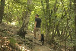
Looking for the shade helps, but it can still be very, very hot!
But there is another reason why it’s important to bring a leash. While it can be quite, expect some unexpected meetings with other wildlife. From cows to mountain goats and from huge bugs to snakes, they all live in the plains and forests of the hills. It’s best to leash your dog when having an encounter and when it comes to the bigger animals like cows, try to stay well away from them. Be careful crossing a group of them through the middle of the group as they might react defensively.
Smaller animals can do just as much damage. A bee sting, a snake bite, it doesn’t happen often, but when it does, it’s good to know what to do. It’s recommended to have a ‘first aid for dogs’ guide with you or at least know what to do in the more common situations. Don’t bother bringing a hard copy book, just download one on your mobile device and you will have it with you all the time.
And then there are the humans. Not everybody likes dogs. Be sure to leash your dog when entering more crowded places. This for sure counts for city centres and towns, but also in restaurants and terraces. And of course, as a responsible dog owner, scoop the poop.
Seasonal tips
Depending on the duration of your hike and the season, bring enough nutrition for your dog. Especially in the summertime, it can get excruciating hot. Your dog doesn’t sweat like you do as it tries to keep itself cool by panting. To assist your dog, water is the absolute number one. And the dog will need loads of it during a hike. If possible, try to plan a route past water. Whether that’s taps, streams or lakes, your dog will be grateful. Carrying water around can be heavy. The best way is to do so is in a rucksack. Don’t bring a shoulder bag as it’s going to ruin your back on the longer hikes. A good idea to bring is a foldable water tray. Do not throw any water out but put it back in the water bottle. You just might need it later. And while as a dog owner you should know, but we can’t stress it enough; Do not leave your dog in the car when it’s hot!
Winter brings another set of unique challenges. Your dog still needs water, but that’s usually not a big problem. The biggest danger is probably the snow. It can be slippery but worst of all, you can’t always estimate the depth and whats underneath. Be careful about letting your dog walk around edges. In fact, if edges are close, it’s recommended to leash your dog and stay well away from it.
And what if it goes wrong?
No matter how well prepared, something unexpected might just happen. Maybe not even to your dog, but to yourself. In that case, it’s nice when you have all emergency options at your disposal. So, bring a fully charged phone and make sure you have an emergency contact. The phone number of a local vet can come in handy as well, just be sure the vet speaks a language you understand. In case of a hike over multiple days or in uninhabited areas, consider bringing other emergency tools like flares in order to leave distress signals.
Do’s and don’ts with your dog
These do’s and don’t pretty much summarize this article in a few pointers. Keeping them in mind will make your hike a relaxing and beautiful experience. Do yourself and your four-legged friend a favour and plan ahead.
Do
- Carry a leash and use it when appropriate
- Bring enough nutrition (water)
- Have a first aid kit
- Bring a phone with emergency contacts
- Clean up after your dog
Don’t
- Go out for too long
- Let the dog roam free in crowded places
- Disturb nature
- Leave the dog in the car in the summertime
- Go out unprepared
Go out and explore
With these tips, you should be able to make a well-considered decision about bringing your dog on your next hiking adventure. While not all hazards can be eliminated, by taking proper care and planning chances are it will be an unforgettable journey for you and your best friend.
Need some recommendations for a walk? Check out our trip to Stoanernen Mandln or our hike at Monte Bollettone.
The post Bringing your dog to the Italian Alps appeared first on Live & Explore.
]]>