On a beautiful but frisky Saturday in the beginning of December I set out to hike the Maridalen Alps. Maridalen itself is a valley north of Oslo. In the valley you’ll find Maridalsvannet, a lake that serves as the primary source of drinking water. 90% of Oslo’s population get’s it’s water from this lake. But I set out to hike the hills, going up to 500 meter above sea level, to check out the spectacular forest and panoramic views.
It’s a very short drive from Oslo city center to get to the starting point, a parking area at the Sandermosveien in Maridalen. On my way to there I pass the Maridalsvannet lake. It’s a strange feeling. Within minutes you go from a busy city, to the quite country side of Oslo.
Once parked and prepared, I start the hike using a route I found online. It serves as a guideline. While it’s still close to the city, the Maridalen Alps is by far not your average city kind of forest. Coming from Amsterdam, this forest makes the places in the Netherlands nothing more than fancy parks. While Norwegians suggest this is not to be compared with the wilderness more north of the country, my assumption that this is a quite rugged area was more than correct.

Preparation is key
Setting out for a 10 km hike in Maridalen with little experience in this area or conditions is very important. While I had a sense of how long the hike would take, it’s still very hard to estimate. Other things to consider are questions like; ‘how is the weather?’, ‘what are the trail conditions?’ and not to forget, how much time do I have before it gets dark?
Knowing I wanted to take some pictures with my DSLR camera, I knew I would be standing still for minutes. Current temperatures of around -5 Celsius can cool you down very quickly. So first of all, I made sure I was wearing proper clothing and shoes. Norwegians love wool. And they are right. Wool underwear in the form of a long sleeved shirt and pants help immensely. On top of that I was wearing a fleece vest and waterproof winter sports clothing. Don’t go under dressed. Live by the rule; You can take off what’s too much, but you can’t put on what you didn’t bring.
Other things I brought was food, drinks and two pairs of gloves. While walking I quickly realized that in the case I got lost or stuck, I had no lights with me. And at this time of the year, twilight hits you around 15.30 and it doesn’t take long before it’s proper dark.
Of course you can take it quite far. What of a battery pack to re-charge your phone? I used mine as a GPS tracker so I could keep track of my location and the route I was planning to walk. I was happy did as at some points during the hike, the snow made it impossible to see the trail, making me wondering left to right with my eyes fixed on my phone screen. Going of track can be very though with the deep snow and in fact a bit dangerous and slippery.
So most important in my case was to start the hike with fully charged equipment, warm clothing and a very good mood.


Following the trail
Starting from the parking area, the beginning of the route eases you in very smoothly. A wide gravel road slowly leads you up into the hills. At this time of the year, many of the little streams of water are covered with ice patches. The snow that has fallen earlier, ensures that you have to stay a bit alert. It can be quite slippery, especially when the ground isn’t level.
Walking on, the wide road abruptly ended and turned into a little trail. A few meters further and you find the first little bridges crossing streams. Well, let me rephrase that. It seems like it used to be a little bridge. It’s now nothing more than a collection of wooden bars covered in ice, snow and rocks. With some agility I jumped and hopped my way over, trying not to get wet by the freezing cold water.
Surprisingly, some patches of green moss aren’t that stable as you think it might be. A layer of water and ice beneath it make it very squishy and would it have been a little less frozen, I’m quite sure I would have gotten myself wet feet.
Further on, it got steep. A look at my GPS route also straight told me I was off track… already… A very steep climb trough, working myself trough trees, branches and stone got me back on track. Not for long though.
Panoramic views over Maridalen
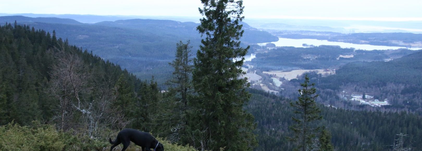
The higher I got, the more hints I got of the spectacular views I was about to see. The more snow too! It’s absolutely wonderful to walk around here. The silence, the clean air, it makes it all worth it. After some time going upwards, just a little break to enjoy the silence made realize I could hear my own heartbeat.
And there it was, the first panoramic view from the Mellomkollen. It gives a majestic view over Maridalen lake and looking even further a glimp of Oslo city and it’s fjord. As I’m an hour and a half into the hike, it’s time for some refreshment while enjoying this view.


Moving on the trail becomes tough and the steep incline and snow make it hard to stay on track. Having my phone in my one hand while the other is touching ground for support, I work my way up to the next view point. It’s here, Midtkollen, where it got really though.
Deep snow, lot’s of elevation changes and no sign of a trail left me wondering again. It’s here I actually got a tiny worried. Navigating this, knowing I only had 2 to 3 hours of daylight left, was hard. I was maybe just half way but already spend 2 hours. And I had no idea how long this rugged path would take me.
It didn’t change my mood though. Around every corner there was another beautiful sight to admire. From frozen lakes to fairy tail kind of trees and moss made me wonder if I would actually spot a real Norwegian troll. Of course I didn’t, they don’t come out in bright daylight. It needs to be very foggy for them to show up. Oh and no, I did not eat shrooms during my hike.
The way down
After finding the trail again using my phone, it became a lot easier. The snow slowly became less and the trail wider. Yet I had to remain vigilant. The ice patches made me slide around while holding my camera in the hand. It sure keeps you sharp and awake.
By now it became clear I was going to make it before twilight. In the last bit, of course I got of track again but following a trail down the side of the hill, I was quite sure it would lead me back to the main gravel road. From there it was a breeze to get back to the car.
All in all I’ve hiked and exact distance of 10 km taking 2 and an half hour of active walking time. This seems fast, but overall, I spend a little less than 4 hours in the Maridalen Alps. Driving home south, with the sunset as final show, this hike made me beg for more. Not today, as I’m toast, but I’ll sure be back soon.
What did I learn?
Well first of all, I might change a few things in my preparation. A bottle of cola and a bag of chips is maybe a bit little. Then the lights. I didn’t need them this time, but it’s better to be safe than sorry. The clothing? Well that was a bit overkill. It did help me a lot during 10 minute brakes to take pictures and such, so I probably won’t change much to it if I know I’ll be doing that.
Other than that, do not go out hiking when the snow conditions are worse! You can’t see the trail at all. I guess if there is a lot of snow, I will be out snowshoeing. Yes, that is actually an activity here I really like to try out.
Other than that, the GPS application I was using did not had such a detailed view of the trails. I highly recommend to either get a good hiking map or print the area from a a great source like Norgeskart.
How to get there?
I got there by car. From Oslo, there is pretty much one way that leads to Maridalen and Maridalsvannet. I recommend you use Google Maps (note that you can make areas offline available)
By train is a very good alternative. Line L3Â (nsb.no) can take you to a station called Snippen from where it’s a small walk to the parking spot I started my hike. But be creative as there seem to be many trails that can get you to the same spots as I have visited.